There are 2 ways to get from Phoenix to Chiricahua Mountains by bus, unknown, or plane
Select an option below to see step-by-step directions and to compare ticket prices and travel times in Rome2Rio's travel planner.
Phoenix (PHX) to Silver City Airport (SVC) flights
Questions & Answers
The distance between Phoenix and Chiricahua Mountains is 236 miles.
The best way to get from Phoenix to Chiricahua Mountains without a car is to bus and travel which takes 5h 18m and costs .
It takes approximately 5h 18m to get from Phoenix to Chiricahua Mountains, including transfers.
What companies run services between Phoenix, AZ, USA and Chiricahua Mountains, AZ, USA?
There is no direct connection from Phoenix to Chiricahua Mountains. However, you can take the bus to Willcox then travel to Chiricahua Mountains. Alternatively, you can take the vehicle to Terminal 4 Station, walk to Phoenix (PHX) airport, fly to Silver City Airport (SVC), then travel to Chiricahua Mountains.
- Website
- advancedaircharters.com
Flights from Phoenix to Silver City Airport
- Ave. Duration
- 1h 12m
- When
- Every day
- Estimated price
- $120–330
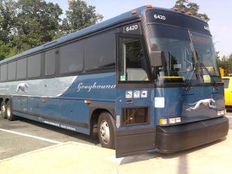
Rome2Rio's guide to Greyhound USA
Contact Details
- Phone
- +1 214-849-8100
- ifsr@greyhound.com
- Website
- greyhound.com
Bus from Phoenix Bus Station to Willcox
- Ave. Duration
- 4h 10m
- Frequency
- Once daily
- Estimated price
- $40–75
- Website
- https://www.greyhound.com/
Want to know more about travelling around United States
Rome2Rio's Travel Guide series provide vital information for the global traveller. Filled with useful and timely travel information, the guides answer all the hard questions - such as 'How do I buy a ticket?', 'Should I book online before I travel? ', 'How much should I expect to pay?', 'Do the trains and buses have Wifi?' - to help you get the most out of your next trip.
Related travel guides
Travelling to the US: What do I need to know?
Read the travel guide
Need to know: Greyhound
Read the travel guide


